

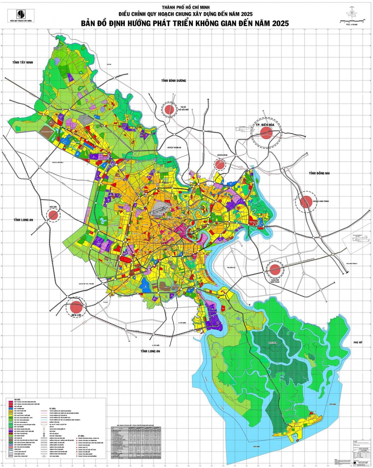
The planning map of HCMC to 2025
Along with Hanoi City, Ho Chi Minh City (also known as Saigon) is a city directly under the central government and belongs to a special city of Vietnam. Ho Chi Minh City (HCMC) is the biggest city in terms of population and scale of urbanization in Vietnam. It is also a major center of economy, politics, culture and education.
Mastering the planning map of HCMC will help you ensure safe transactions and avoid risks. Simultaneously, it also contributes to the accurate calculation of investment advantages when trading, transferring, purchasing or selling in the real estate market in HCMC.

1. The scale and nature of the planning map of HCMC
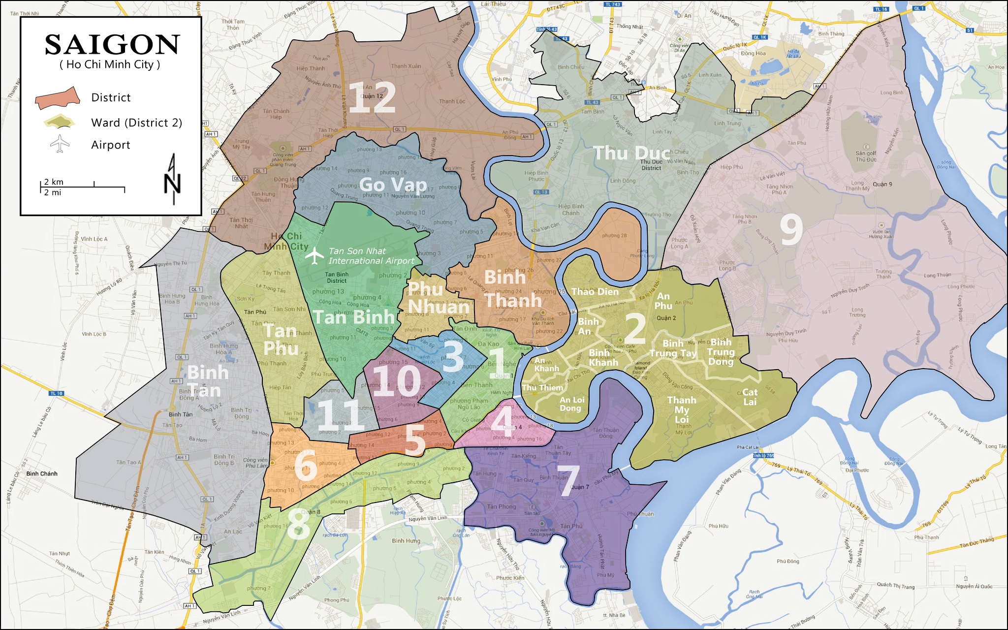
General scale: HCMC with an area of 2,095m2 includes 1 city, 21 districts. After the first planning project in 1993, there was an adjusted project in 1998, followed by the general planning adjustment project in 2020. And the latest is the planning map of HCMC to 2025.
Nature: HCMC is a special city, a major center of economy, culture, education and training, science and technology, has a crucial political position in the whole country. Moreover, this is also an international exchange focal point, the center of multi-sector industry and service in the area and Southeast Asia.
Target: This planning map of HCMC aims to bring the city to a sustainable development. At the same time, it still has to ensure the harmony between the economic developments with the preservation of historical, cultural relics and environment, security, defense protection towards regional linkage. It is all about:
- Forming a civilized and modern city
- Contributing to the development of the South region and the whole country
- Simultaneously, gradually turning the city into the center of industry, service, science and technology of the area and Southeast Asia.
2. Information about the planning map of HCMC to 2025
a. The development planning towards space
Saigon will be planned according to the “multipolar” model. It means that the city will divide into many centers. As follows:
SOUTH PLANNING
The South includes District 7, Nha Be District. This is an area with many canals and rivers. Furthermore, the land fund for urban development is still abundant. Thus, the city lays down as a policy the development of technical infrastructure for water drainage.
EAST PLANNING
The East includes District 2, District 9 and Thu Duc. This is the area where Ho Chi Minh – Long Thanh – Dau Giay Highway corridor passes. Therefore, the planning map of the Eastern area in HCMC will concentrate on developing urban areas along Hanoi Highway such as: high-tech area, software park area of Vietnam National University Ho Chi Minh City.
SOUTHWEST PLANNING
The Southwest planning includes Tan Phu District, Binh Tan District and Binh Chanh District. These are all districts with the basic development. Hence, City People’s Committee advocates prioritizing the development of infrastructure which is appropriate in accordance with available conditions here.
NORTHWEST PLANNING
The Northwest planning includes District 12, Hoc Mon District, Cu Chi District. They are districts located on the outskirts of the city. They are suitable for developing to new urban areas because the land fund is good and abundant. That is the reason why the city will invest in the technical infrastructure synchronously to match with the social infrastructure.
b. The development planning towards zones
In addition to the city planning according to the “multipolar” model, People’s Committee of HCMC also approves the zoning project as below:
– The urban development zone will include 13 existing inner districts with 6 new districts, towns belonging to districts, newly developed urban areas.
– The industry development zone deploys in new districts such as Cu Chi District, Hoc Mon District, Binh Chanh District and Nha Be District.
– Ecological and tourist zones develop along Saigon River, Nha Be River, Dong Nai River and Can Gio Mangrove Biosphere Reserve.
– The agricultural zone will be combined with the developing ecological belt in Cu Chi District, Hoc Mon District, Binh Chanh District and Can Gio District.
– The natural conservation includes the ecological conservation and restoration in Can Gio Mangrove Biosphere Reserve, together with Special Use Forests in Cu Chi District and Binh Chanh District.

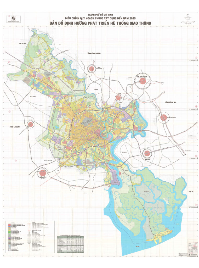
c. The development planning towards traffic
+ Road: traffic axis is built according to the standard of urban highway. It embraces 3 ring roads (ring roads no. 2, 3 and 4); external centripetal axes: HCMC – Bien Hoa – Vung Tau axis (Hanoi Highway); HCMC – Thu Dau Mot – Chon Thanh axis (National Highway no. 13); 1K National Highway – Binh Phuoc axis; HCMC – Moc Bai axis (2 routes); HCMC – Trung Luong – Can Tho Highway axis; National Highway no. 1 axis to the west; HCMC – Long An axis (provincial road no. 10); HCMC – Go Cong axis (National Highway no. 50);
+ Railways: renovate and upgrade Thong Nhat railway line (North-South) in HCMC, Trang Bom – Binh Trieu section. In which to build Bien Hoa by-pass to the South and a new section of elevated (or underground) railway: Binh Trieu – Hoa Hung – Tan Kien; build 2 new railways to Bien Hoa and Loc Ninh; the HCMC – Nha Trang highway electrification double railway connecting at Thu Thiem station as expected; build a new specialized railway from the national railway to Cat Lai and Hiep Phuoc ports. All are 6 lines with the total length of about 226km.
+ Waterway: renovate and dredge to ensure circulation for two streams of Long Tau and Soai Rap rivers to the sea; 4 streams to the Mekong Delta provinces; 1 stream to Ben Suc, ensuring the standard of level III river.
+ Airway: Tan Son Nhat International Airport will become an air transit point of the area and the world; renovating and raising the capacity to about 20 million passengers/ year. Develop infrastructure for the airport having enough capability to receive modern planes and operate 24/24 hours. Build Long Thanh International Airport (Dong Nai Province) with the capacity of 100 million passengers/ year.
Saigon Apartment has provided detailed information about the planning map of HCMC. Hope it will be useful for you!
You may concern below information:
View of the real estate market in District 2, Ho Chi Minh City
The Metro line 1 and real estate market
Dennis


